| Objectives of the Study
*Gain a better understanding of the total
Klamath watershed and its hydrologic history
*Develop multi-year hydrographs at key
locations in the watershed to look for long-term
trends in flows of major tributaries and the
Upper Basin
*Examine Klamath Project long-term
operations to determine the probability of
achieving flow requirements recommended in Hardy
Reports
|
Data Sources and Limitations
*Streamflow data are from Bureau of Reclamation
and U.S. Geological Survey records available on
the Internet
*Years of record vary for various subbasins in
the watershed
*Minimum Instream Flows from Hardy studies are
taken directly from Hardy Phase I Final Report
and Hardy Phase II Draft Report
*Klamath Project water diversions reported
include agricultural and refuge use as
calculated by Jim Bryant at the Bureau of
Reclamation
*Data are summarized over years to mask the
inherent and large variability between water
year types due to precipitation fluctuations
|
|
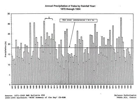
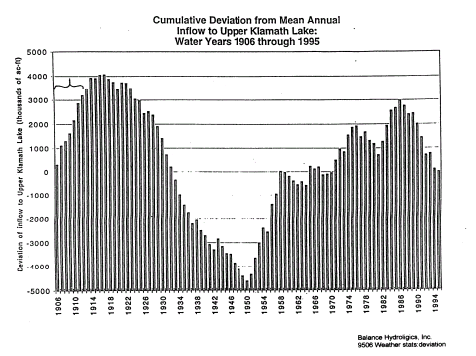
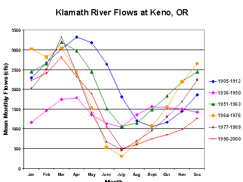
Selective Use of Data
*Major studies and reports shaping public policy
have used a non-typical hydrologic period as the
basis for historical flows *Reports by Balance
Hydrologics, Inc. and Hardy Phase 1 use flows at Keno,
OR from 1905-1912 for estimating pre-Klamath
Project Upper Basin flows
*Balance Hydrologics, Inc. used a 4% correction
to account for 1905-1912 being an above average
precipitation period
*Compared with long term records, 1905-1912
experienced precipitation 21% above normal in
Yreka, CA and 4% above normal in Klamath Falls
*The Bureau of Reclamation estimated inflow to
UKL at 34% above normal in 1905-1912
|
 |
|
Changes in Upper Basin
Hydrology
*The Lost River Slough was dammed in 1890 to
stop drainage of excess flows from Klamath River
to Tulelake
*Construction of a railroad through Lower
Klamath Lake between 1907-1911 prevented
overflows from Klamath River to Lower Klamath
Lake, reducing large evaporation losses
*Both changes resulted in increased flows at
Keno compared with pre-settlement hydrology
*Pre-settlement, the Lost River system was a
closed basin with no access to Klamath River
*Project features now allow diversion from the
Gerber, Clear Lake, Lost River system to Klamath
River
*Direct access to Klamath River is available
from Tulelake through Lower Klamath Refuge and
the Straits Drain |
 |
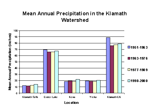
Annual precipitation in the
Klamath Basin
*Long-term NOAA precipitation records are
available for Klamath Falls, Crater Lake, and
Keno, Oregon, and Yreka and Klamath CA.
*Total annual precipitation is charted
for each location for 1951 - 2000.
*Average precipitation for multi-year
periods that will be used for streamflow data
presentation are quite similar at each location. |
 |
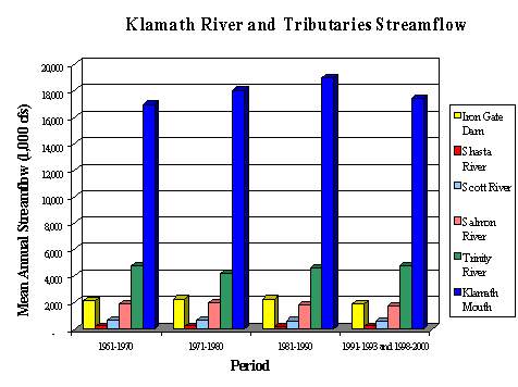
| Streamflows for Klamath River
Tributaries *Iron
Gate Dam records begin in 1960
*Data for the Klamath Mouth is not available for
1994-1997
*The major tributaries contribute about 54% of
flow at the mouth for the period of record.
*Remaining flows are from smaller tributaries
and include 360 TAF (thousand acre-feet) of
accretions from Keno to Iron Gate Dam
|
 |
|
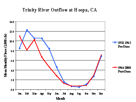
Trinity River Annual
Hydrograph
*Shape of hydrograph is very similar to
Klamath mouth hydrograph
*Significant change in April through June for
periods before and after Trinity Diversion
*Diversion was about 1.1 MAF (million acre-feet)
in 1964-1986 and 0.73 MAF from 1987-2000 (CDWR)
|
 |
|
Trinity Hydrograph Pre- and
Post- Diversion
*Important to note that diversion occurs high
in the Trinity Basin and only affects about 20%
of the total Trinity system measured at Hoopa,
CA
*Hydrograph suggests diversion occurs between
March and July
*February dip in post-diversion hydrograph is
related to filling of Trinity reservoirs
*August through December graphs are identical
|
 |
|
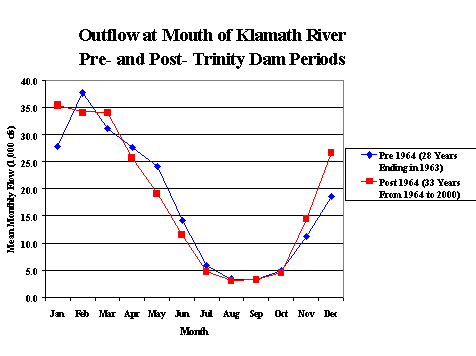
Klamath
Mouth Hydrograph pre- and post-Trinity River
Dams
*Main difference coincides with reduced
post-dam spring Trinity River hydrograph
*August and September flows nearly identical
pre- and post-Trinity dam
*Period of apparent shortage coincides with
request for increased flows for smolt
out-migration
|
 |
|
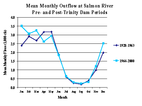
Salmon River Hydrographs
*No out of stream diversions from Salmon
River, but seasonal hydrograph coincides with
Trinity’s
*Hydrographs show similar trends for varied
flows from December through April, but
consistent low flows in August and September
*Pre- and post- Trinity Diversion periods have
nearly identical hydrographs from June through
October |
 |
| Scott River Hydrographs
*Same seasonal hydrograph trends
as observed for Trinity and Salmon Rivers
*Diversions for agriculture
are estimated at 70 TAF or about 15 % of Scott
River watershed yield (CDWR)
*Study by Drake, Tate, and
Carlson reported precipitation accounted for
75-80% of fall flow variability
|
 |
| Shasta River Hydrographs
*More uniform hydrographs across
years than other tributaries
*CDWR estimates agricultural
diversion is about 100 TAF annually
*Diversion represents about 40
% of Shasta yield and 25 % of Klamath Project
diversion from UKL and Klamath River
|
 |
|
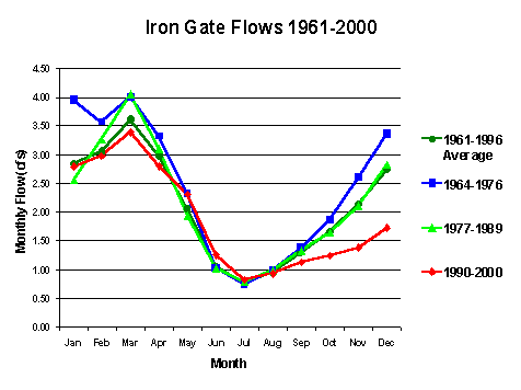
Iron Gate Dam Hydrographs
*Annual discharge declined from 1.75 MAF in
1964-76 to 1.38 MAF in 1990-2000
*No significant increase in Klamath Project agriculture
diversions from 1960s to present
*Mean flows from May through August were similar
in all periods |
 |
|
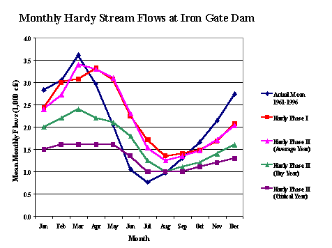
Meeting Hardy Minimum
Instream Flows at Iron Gate Dam
*Hardy Phase I recommended an
"average" year flow regime requiring annual
discharge at Iron Gate Dam of 1.62 MAF
*Average 1961-1997 Iron Gate flow is 1.53 MAF
*Total annual flows at Iron Gate were less than
Hardy Phase I "average year" flows in 25 of the
42 years from 1961-2002 |
 |
|
Meeting Hardy Minimum
Instream Flows at Iron Gate Dam
Revised Hardy Phase II
flow regimes set 5 hydrologic year-types based
on projected April-September inflow to UKL:
*Critical: Inflow < 286.8
TAF
*Dry: Inflow 286.8 – 458.3
TAF
*Average: Inflow 458.4 –
568.5 TAF
*Above Avg: Inflow 568.6 –
785.2 TAF
*Wet: Inflow >785.2 TAF |
 |
|
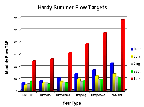
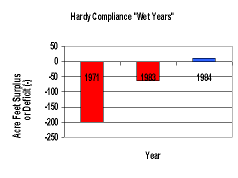
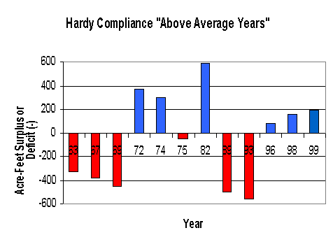
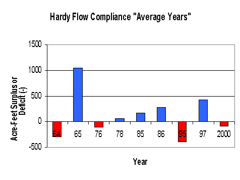
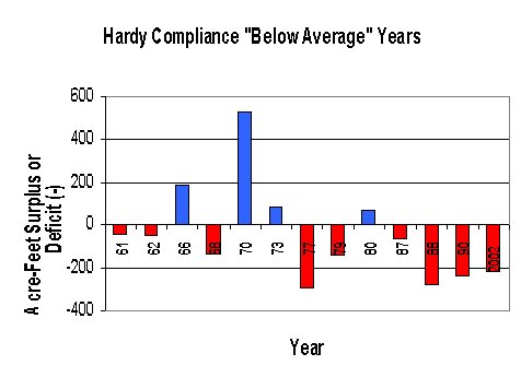
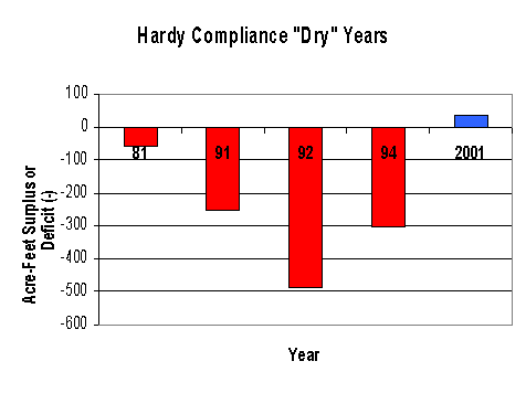
Can Hardy Phase II Targets
for Iron Gate Dam be Met?
*No consideration for minimum lake
elevations, overflows in spill mode, or timing
of flows to meet summer targets in the analysis.
*Evaluation only considers total annual Iron
Gate flows and whether individual years achieved
those flows based on year type targets
*Results are charted by year type for 1961-2002
*Charts show surplus or deficit (-) by year type
|
 |
| |
 |
| |
 |
| |
 |
| Williamson River Flows at
Modoc Point Road
*Williamson River accounts for about 46 % of
inflow to UKL according to several studies
*Williamson River watershed
yield per inch of precipitation at Klamath Falls
or Crater Lake has declined significantly over
the past 50 years
*Changes in the upper
Williamson, Sycan, and Sprague Rivers seem
apparent
|
 |
| Klamath Watershed in
Perspective Summary
*The Upper Basin above Iron Gate Dam, including
Klamath Project diversions, accounts for about
15 % of annual flow at the mouth of Klamath
River over past 40 years
*Klamath Project agricultural
water use has not changed significantly in the
past half century
*High summer flows requested
for environmental use are only potentially
available because of storage designated for
agricultural irrigation
|
Klamath Watershed in
Perspective Summary *All
tributaries in the Klamath system produce
hydrographs with widely varying winter and
spring flows but consistently low summer flows
*Trinity diversions represent
about 20 % of river yield and appear to mainly
affect the spring hydrograph for Trinity and
mouth of Klamath
*Watershed yield above UKL
appears to have declined in recent decades
|
| Klamath Watershed in
Perspective Summary *Hardy flow regimes requested
for summer months could not be met in a
significant number of years even if Klamath
Project received no diversions from UKL or
Klamath River
*Basing historical flows on
1905-1912 results in unachievable expectations
|
Klamath Watershed in
Perspective Summary *The
1905-1912 period used to model flows is the only
period since 1905 when streamflow records are
unavailable in all other reaches of the
watershed
*This fact precludes the
ability to compare the yield at Keno, OR with
flows in the Lower Klamath River Basin or other
tributaries
|