Our Klamath Basin Water Crisis
Upholding rural Americans' rights to grow food,
own property, and caretake our wildlife and natural resources.
Our Klamath Basin
Water Crisis
Upholding rural Americans' rights to grow food,
own property, and caretake our wildlife and natural resources.
https://www.capitalpress.com/opinion/columns/commentary-natures-dams-on-the-klamath-river-blocked-fish-for-millennia/article_57cf799a-1724-11ec-9256-b78d887a7c2c.html
Nature's dams on the Klamath River blocked fish for millenniaCommentary
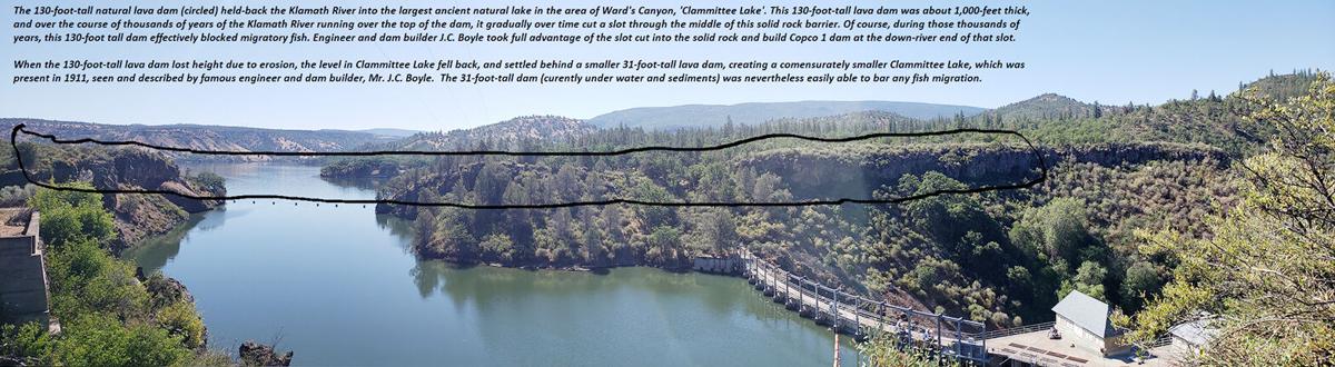
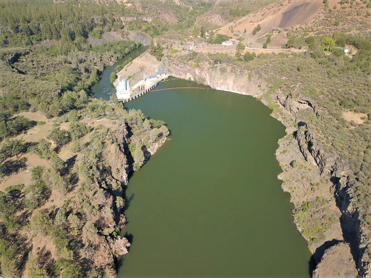
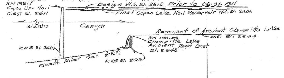
Numerous published geologic studies and present-day observations show that over the course of past millennia, a series of no less than five lava flows crossed the Klamath River. At least two of these lava flows dammed the Klamath River at Wards Canyon. These lava flows, which dammed the Klamath River, are also called "reefs" or "dikes" by geologists. These lava flows formed tall dams that without doubt blocked fish migration for millennia. (See Fig. 1) One of those five dams was 130 feet tall off the riverbed and was 1,000 feet thick! (See Fig. 2) The slot that was eroded-through the 1,000-foot thick, massive 130-tall lava dam is seen in image Fig. 2. The modern dam, Copco 1, was built in the downriver end of the slot, and can also be seen in the drone photo (Fig. 2). This 130-tall natural lava dam on the Klamath River formed a large lake called Clammittee Lake that was five miles long and one mile wide. Over the course of thousands of years, the Klamath River finally cut a narrow notch down through this massive natural lava dam. And as the water level in Clammittee Lake fell, the Klamath River eventually ended up being held back by a smaller 31-foot-tall lava dam a quarter-mile upriver, which maintained a smaller version of Clammittee Lake through 1911 and the completion of Copco 1 dam. In 1911, when the famous engineer and dam-builder J.C. Boyle arrived at Wards Canyon to build Copco 1 dam, he noted the existence of the 31-foot-tall natural lava dam that held back Clammittee Lake. J.C. Boyle made a detailed drawing of that 31-foot-tall lava dam and its lake (Clammittee Lake). That drawing was published in 1913 and that image is associated to this article for reference in Fig. 3. Figure 3 shows the flow of the Klamath River over the top of that natural lava dam, the riverbed and the location of Copco 1 dam a quarter-mile downriver. J.C. Boyle took advantage of the slot cut through the 30-foot-tall lava dam that was a quarter-mile downriver from the smaller 31-foot-tall lava dam. At farthest downriver end of that slot, J.C. Boyle integrated his new dam (Copco 1) into the solid rock that was part of Nature's massive lava dam. The resulting modern dam was nearly as tall as the original natural 130-foot-tall dam, and brought the water level in Clammittee Lake back up to where it had been thousands of years before, restoring that ancient lake to its full glory where a myriad of unique species of flora and fauna had evolved and remain present today. Today, Clammittee Lake is within the present footprint of Copco Lake, which is situated behind Copco 1 Dam. Copco lake alone holds 25 billion gallons of fresh water. The foregoing evidence belies the premise argued by dam removal proponents that fish from the lower Klamath River basin had allegedly migrated past Wards Canyon. Rock solid evidence, geology, proves that is a false premise. William E. Simpson II is a naturalist studying the wildlife in the area around the Klamath dams. He is the author of two published books and more than 100 published articles on subjects related to wild horses, wildlife, wildfire and public land management.
==================================================== In accordance with Title 17 U.S.C. section 107, any copyrighted material herein is distributed without profit or payment to those who have expressed a prior interest in receiving this information for non-profit research and educational purposes only. For more information go to: http://www.law.cornell.edu/uscode/17/107.shtml |
Page Updated: Tuesday September 21, 2021 02:21 AM Pacific
Copyright © klamathbasincrisis.org, 2001 - 2021, All Rights Reserved